在我的工作中,我经常遇到从OpenStreetMap导出数据的任务。OSM是一个了不起的数据源,您可以从中至少获取景点,至少城市区域,至少街道以研究行人通行能力,以及所有其他信息。
那只是与他们一起工作的过程开始让我感到无聊。要检索一些非平凡请求的数据,您需要学习Overpass请求语言,或者编写脚本并以OSM XML格式四处浏览。
第一百次进行这些操作时,我考虑过要创建一些更简单,更方便的工具。而现在,他已经准备好- https://yourmaps.io,OpenStreetMap的出口描述的可视化编辑器。在编辑器中,您可以将鼠标悬停在一个图形上,该图形的每个节点将代表OSM对象流上的一个操作或过滤器,然后将结果下载到GeoJSON中。
这是一个图形示例,该图形选择给定市政区内的所有学校,然后在它们周围建立300米的缓冲区:
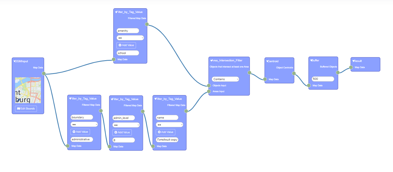
作为工作的结果,我们获得了 GeoJSON格式的多边形集,然后可以将其导入QGIS或其他软件。
— , Rete.js, -.
Rete.js
Rete.js — JS , . , .
, Rete . OpenStreetMap — .
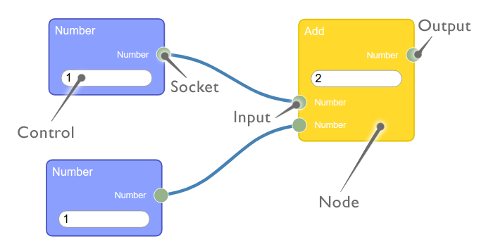
(node), (component). , ( ). data, (, , )
Rete . : , ( ) .
, , , , - .
— , , ( ). , - , - jquery 220, . , .
InputControl Rete, .
var SelectComponent = {
template: '<select></select>',
data() {
return {
value: ""
};
},
methods: {
update() {
this.putData(this.ikey, $(this.root).val())
}
},
mounted() {
let jqueryRoot = $(this.root)
for (let idx = 0; idx < this.values.length; ++idx) {
let v = this.values[idx]
jqueryRoot.append($("<option></option>")
.attr("value", v[0])
.text(v[1]));
}
let currentVal = this.getData(this.ikey)
if (currentVal === undefined) {
currentVal = this.defaultValue
this.putData(this.ikey, this.defaultValue)
}
jqueryRoot.val(currentVal);
const _self = this;
jqueryRoot.change(function() {
_self.root.update()
})
}
}
class SelectControl extends Rete.Control {
constructor(emitter, key, values, defaultValue) {
super(key);
this.key = key;
this.component = SelectComponent
this.props = { emitter, ikey: key, values: values, defaultValue: defaultValue};
}
}
,var AddTextFieldComponent = {
template: '<button type="button" class="btn btn-outline-light">' +
'<i class="fa fa-plus-circle"></i> Add Value</button>',
data() {
return {
value: ""
};
},
methods: {
getCount(node, prefix) {
let count = 0;
node.controls.forEach((value, key, map) => {
if (key.startsWith(prefix) && value instanceof InputControl) {
++count;
}
});
return count;
},
update(e) {
let count = this.methods.getCount(this.node, this.prefix)
this.node.addControl(new InputControl(this.editor, this.prefix + count))
this.node.update()
this.emitter.view.updateConnections(this)
this.putData(this.iKey, count + 1)
}
},
mounted() {
const _self = this;
this.root.onclick = function(event) {
_self.root.update()
}
}
};
class AddTextFieldControl extends Rete.Control {
constructor(emitter, key, prefix, node, inputPlaceholder) {
super(key);
this.key = key;
this.component = AddTextFieldComponent
this.props = { emitter, iKey: key, prefix: prefix, node: node, inputPlaceholder: inputPlaceholder};
}
}
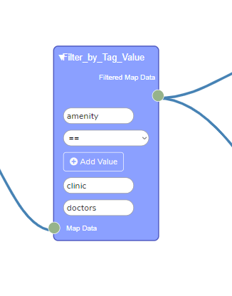
class FilterByTagValueComponent extends Rete.Component {
constructor(){
super("Filter_by_Tag_Value");
}
builder(node) {
var input = new Rete.Input('osm',"Map Data", osmSocket);
var output = new Rete.Output('osm', "Filtered Map Data", osmSocket);
var tagNameInput = new InputControl(this.editor, 'tag_name')
var modeControl = new SelectControl(this.editor,
"mode",
[["EQUAL", "=="], ["NOT_EQUAL", "!="], ["GREATER", ">"], ["LESS", "<"], ["GE", ">="], ["LE", ">="]],
"EQUAL")
node.addInput(input)
.addControl(tagNameInput)
.addControl(modeControl)
.addControl(new AddTextFieldControl(this.editor, "tag_valueCount", "tag_value", node, "Tag Value"))
let valuesCount = 1;
if (node.data.tag_valueCount !== undefined) {
valuesCount = node.data.tag_valueCount
}
node.addControl(new InputControl(this.editor, 'tag_value'))
for (let i = 1; i < valuesCount; ++i) {
node.addControl(new InputControl(this.editor, 'tag_value' + i))
}
return node
.addOutput(output);
}
}
:
.
, JSON ( Rete ), , .
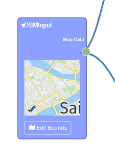
OSM
, .
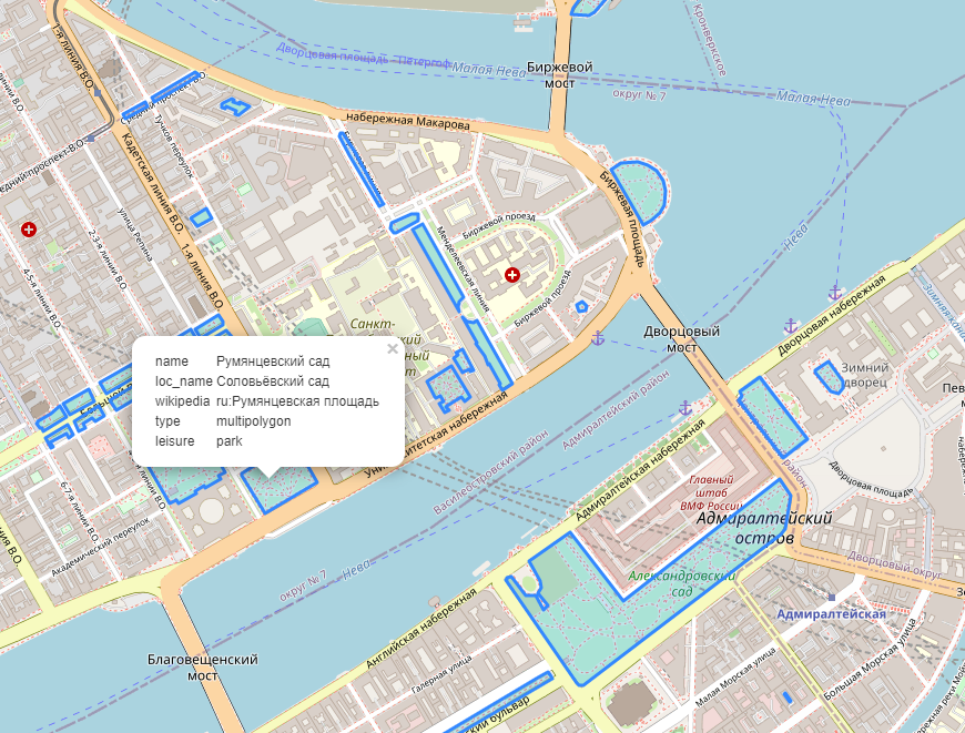
: ( leisure=park, OSM):
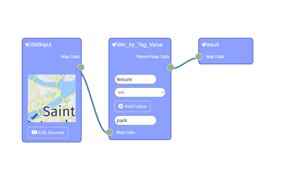
— , OSM , , . ( ( Java) — ), , , .
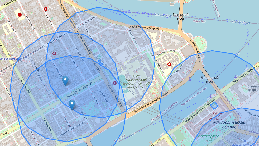
, :
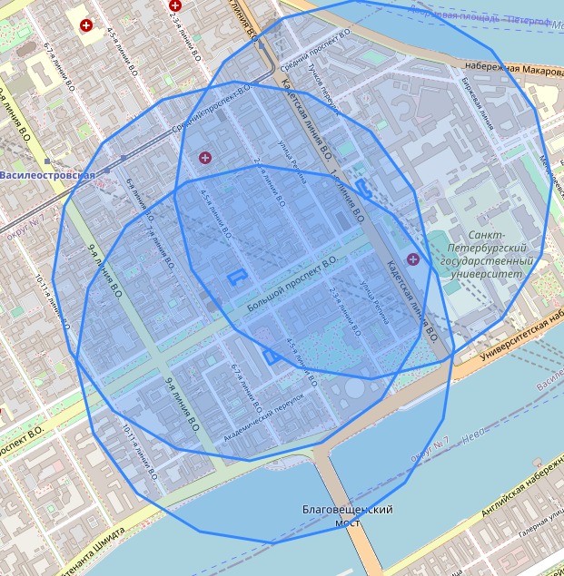
: 500- :
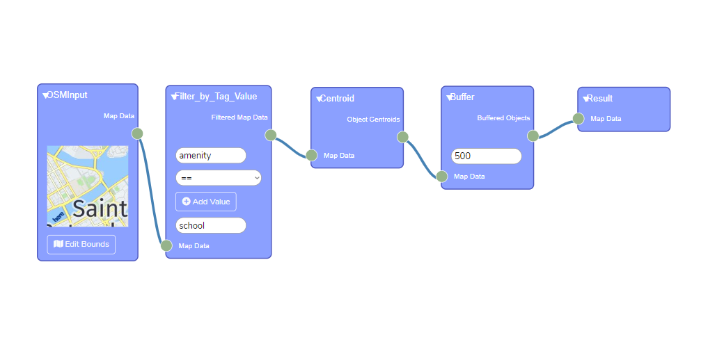
, amenity=school, ( — ), .
, . - .
, , ? : ( ), , , Union. :

… . -, — , .. . , amenity=school , , . , .
, , - . :
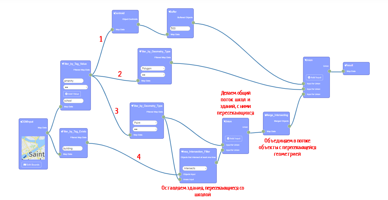
. . — 4, 3. .
. .. - -, .
:
Rete.js YourMaps .
将来,我计划在其中添加更多内容-例如,不仅可以从OSM下载数据,还可以从我的GeoJSON文件,更多类型的操作和过滤器等下载数据。
这项服务可以帮助我个人。例如,当学生需要在OSM卡上快速显示某些内容时-我不再需要运行QGIS并记住复杂的Overpass查询语言,我只需几次鼠标移动就可以单击所需的图形,只需几秒钟即可对其进行处理,您可以立即看到结果。
希望对您中的某些人有用。与往常一样,我随时准备在评论中听取建议和希望,或者您可以将其发送至evsmirnov@itmo.ru