Greetings, dear ones!
What if I say that depth, whatever you mean by it, is one of the most difficult to measure accurately? At what depth does a submarine sail? What is the depth of the mariana trench? At what depth does the Titanic lie? If you are not lucky with the parameters, then in the first kilometer of depth, you can make a mistake of about 30-40 meters and 200-300 meters at the 6th kilometer using a pressure sensor. If you prefer an echo sounder, then in case of a failure of circumstances that you did not take into account, the error on the first kilometer will be 100 meters, and on the 6th - a whole kilometer. Of course, you can still use a long rope ... But there, as you know, its pitfalls.How this could happen and how to do it right I will tell under the cut. In addition to the article, there is an Open-source library in C # / C / Rust / Matlab / Octave / JavaScript and a couple of online calculators for demonstration. The article will be useful to developers of underwater equipment, the number of which over the past five years has grown significantly.So, for starters, we immediately make a reservation that two different quantities are often called depth:
- and the vertical distance from the surface of the water to the point where this depth is measured,
- and the vertical distance from the surface of the water to the bottom.
In the first case - this is the depth of immersion , and in the second - the depth of the place .There are exactly two and a half fundamental ways of changing these quantities, as I have already mentioned:- by hydrostatic pressure of a liquid column, i.e. using a pressure sensor;
- sound propagation time - echo sounder
- along the length of the rope released overboard =)
Everything is clear with the rope, but let's deal with the other two. Today we will analyze:Method 1 - By the pressure of the liquid column
We all know from the school course of physics the formula of hydrostatic pressure of a liquid column:
From it it is easy to calculate the height of the liquid column (i.e. the depth in our case), not forgetting the atmospheric pressure :
We multiply by "100" if we want to get the depth in meters, measure the pressure in millibars, the density of water in kg / m ^ 3, and the acceleration of gravity in m / s ^ 2.Let's ignore the accuracy of specific devices, even if they are super accurate.The problem is that no member of the formula is a constant. Even atmospheric pressure can change over the course of an hour.How is atmospheric pressure affected?
Pressure at the surface of the sea can vary between 641-816 mm. Hg. Art. , or, the same in millibars: from 855 to 1087. If you just take it for Since the standard value is 1013.25 mbar, depending on the weather, you can already get an error of 40-50 centimeters, both in "plus" and in "minus".What about gravity acceleration?
I’m afraid to seem Cap, but still I remind you that our earth rotates flat , and due to centrifugal force, it attracts less at the equator than at the poles.If we don’t tinker with and do not take into account gravitational anomalies due to different densities of terrestrial rocks, mountains, depressions, changes in the speed of rotation of the earth from foliage dumped by terrestrial trees and the movement of juices along their trunks, then we are quite happy with the standard dependence of the acceleration of free fall on geographic latitude. The so - called WGS-84 Gravity formula .According to this formula, the gravitational acceleration varies from 9.7803 m / s2 at the equator (0 ° degrees latitude) to 9.8322 m / s2 at the poles (90 / -90 ° latitude).Let's say we take the standard valuegravitational acceleration 9.80665 m / s2, how much will we make a mistake in the worst case?This is illustrated in the image below. On it, a blue graph shows the error in determining the depth at the equator, if we use the standard valueand the orange graph is the same error at the poles. That is, if we substitute the standard value in the formulaand let's go diving somewhere closer to the equator, then at 100 meters we’ll make a mistake only 20-30 centimeters, at a kilometer - at 2.5-3 meters, and at 9-10 kilometers ( Challenger Abyss , by the way, is located at 11 ° north latitude) the error will be already 25-30 meters. Those. the real depth will be greater than that which we will measure.
And how does the density of water affect?
In the worst way. If the first two components of the error are taken into account quite simply, and their contribution is very modest, then with the density of water the story is more intricate.The fact is that in the simplified case the density of water is a function of temperature, pressure and salinity.That is, it is not enough to measure pressure, atmospheric pressure, take into account the geographical latitude of the place. You also need to know the temperature and salinity of the water.To determine the density of sea water in a (reasonable) range of conditions in practice, the most widely used formula is from the work of Chen and Millero (Yes, UNESCO is also doing this!)Suppose we measured both temperature and salinity, but the compressibility of the water remains - a change in density with pressure (i.e., with depth), and to determine the height of the liquid column we need to sum the heights of the elementary columns at which the pressure changes by some small amount . In general, this is of course the integral, but in order to immediately bring some practical value, we write it like this:
N is the number of pressure break intervals to measured .The density depends on the pressure almost linearly, and it makes no sense to consider such a sum due to allowance for compressibility alone, but I have given this formula here for a reason.The fact that density depends on three parameters is half the trouble. The difficulty lies in the fact that all these parameters can vary greatly with depth. In this case, it is customary to talk about the temperature and salinity profiles. This is how, for example, a profile from the Arctic looks like: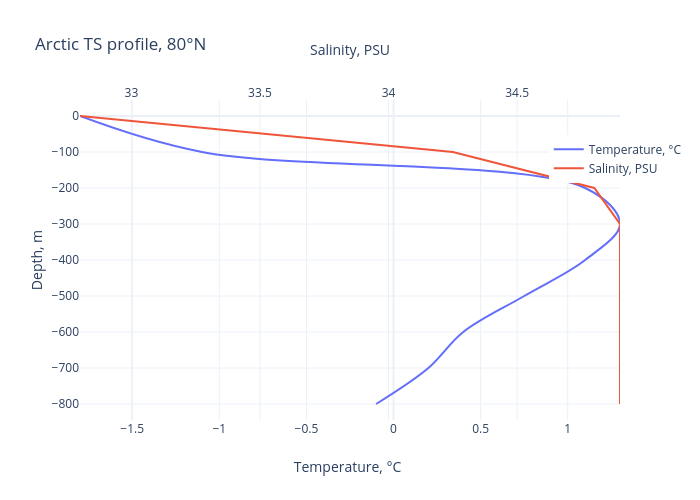 This is from the northern part of the Pacific Ocean:
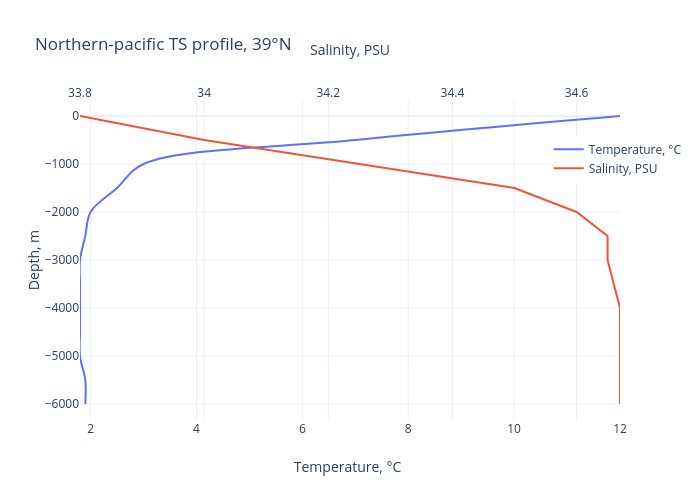 And so, for comparison - from the south of the Atlantic:
 For example, if we imagine that we are plunging into the northern part of the Pacific Ocean (39 ° N, 152 ° VD)we take into account atmospheric pressure and the geographical latitude of the place and the compressibility of the water, and our pressure sensor shows 100 Bar (~ 1000 m), and we take the temperature and salinity at the measurement point, but do not take into account the profile, we will make a mistake with a depth of 2 meters.I specifically washed down the online calculator and added three test profiles (they can be switched with buttons) so that everyone can try it for themselves.If now just switch the profile to the “South Atlantic” and try to recount, then we will see that the difference has grown to 6 meters. Let me remind you: everything, even the compressibility of water, we have already taken into account! The error is associated only with the presence of a profile — layers of different temperature and salinity in the water column.Naturally, everything changes with the changing seasons and with changing the time of day. In summer (in the northern hemisphere, in the winter in the southern hemisphere), the upper layer warms up, and in winter it cools down. Storms mix water, rains wash away mud from land and carry rivers into the seas, melt snow and glaciers.This is to say that you can’t just measure and knock out all the temperature and salinity profiles in all the seas and oceans in granite - everything flows, everything changes. And if suddenly you are going to dive to tangible depths and you do not have a temperature profile - I won’t believe your record)
Materiel
As I mentioned at the beginning of the article, I collected everything necessary for calculating the depth in the library and put it on GitHub .It has also been translated into JavaScript , and I use an online calculator as an interactive example of its use .PS
Thank you for your attention, I will be sincerely grateful for constructive criticism, error messages, suggestions and suggestions.In the next article I will analyze the second way to determine the depth - by echolocation.