Flexibility determines success.
 In the modern world, the use of software for modeling deposits and mining is no longer something extraordinary. There are a sufficient number of software products on the market that, depending on the modification of the manufacturer, cover almost all the needs for mining and geological conditions of enterprises and the processes performed by mining engineers, geologists and mine surveyors.The Russian features of this industry, obvious to the specialists working here, are somewhat different from the principles that guide foreign companies - the main producers of mining and geological software (hereinafter GIS - geoengineering systems), offered today on the domestic market.The Russian reality is that enterprises need GIS adapted to the conditions in which they work for a long time and habitually. It is also important that in nature there are no identical deposits and, accordingly, each mining enterprise is unique and has its own individual characteristics and nuances in the engineering support of mining operations.Examples of such distinctive features include the type of mineral and the morphology of its occurrence, methods and systems for developing the deposit, the technology of mineral processing, which creates exceptional working conditions that distinguish enterprises from each other.It is important that the information technologies imposed on the engineering staff do not fundamentally break down the established production processes carried out by specialists, which is inevitable when the third-party GIS is thoughtlessly planted in its original format. A change in the established way of work of specialists can, at best, cause them to dislike the new software, and at worst, kill the new technology in its infancy, even before its full implementation.Years of experience in sales and implementation of various GEOVIA softwareallows us to say unequivocally that in the basic configuration, foreign GIS do not meet the needs of Russian engineers in solving their everyday tasks. This statement is confirmed by the fact that Russian users regularly receive requests for such a GIS functionality that goes beyond the presentation of foreign developers about the needs of our market. This is true for all software products in demand in Russia, including software of Russian origin, which, as a rule, is refined and honed by the manufacturer for the needs of the enterprise during its operation. This creates the illusion that Russian packages fully meet the needs of our market, which is often not true.As a rule, a GIS as standard is a set of certain elementary specialized tools, the competent use of which allows solving rather complex problems. At the same time, obtaining the final result can be achieved both in several steps, and by pressing one or two buttons.Of all the existing options for achieving the goal, the most interesting for the user is always the one that requires a minimum of resources (time-money-people). Among GEOVIA products, such a product as Surpac entered the Russian market most harmoniously .According to our observations, the most significant arguments when choosing it are the Russification of the package, the user-friendly interface and the ability to adapt the product to the individual needs of the user.The concept of adapting the program to the needs of the enterprise proposed by the developers of Surpac software allows users to independently add and develop a software product using the common TCL language, customizing the program for their own tasks.In addition, when using Surpac software, the missing software functionality, the so-called “buttons,” can be logically and mathematically described using the aforementioned programming language. The “buttons” created in this way can be further used as an additional toolkit for engineers.It's no secret that no software works on its own. This is true for complex engineering software as well as for simple office applications.So, the effective use of GIS is unrealistic without the participation of interested specialists with a sufficient level of qualification. Thanks to the engineering idea and creative approach of specialists using the TCL language directly on the spot, the enterprises had the hope of having at their disposal a set of “buttons” for the implementation of individual logically completed daily operations, with a certain periodicity, performed by the linear personnel of the enterprise.Experience in using Surpac in the industry has shown that enthusiastic and interested professionals can tailor the program to their needs, completely changing it to such an extent that the functionality and interface become less recognizable.For several years working with specialists from the Russian division of GEOVIAaccumulated experience in successfully solving tasks of automating everyday processes and implementing a number of specific algorithms.Currently, the most vulnerable part of most mining and geological packages is their inability to ensure that surveying operations are in compliance with current regulations. In most cases, when using any software at the enterprise, surveying services are forced to replenish the compulsory mining and graphic documentation both in electronic form and on standard hard paper media, i.e. actually do double work. This does not add to users a positive attitude towards software.To ensure compliance with regulatory documents (not without the participation of customers), specialists from the Russian division of GEOVIA developed specialized modules and tools for maintaining mine surveying tablets and longitudinal / transverse sections in the form that is accepted at the enterprise and meets certain standards and rules.The new functionality allows you to print information on paper with a certain frequency, which is specified in the corresponding paragraph of the instructions for the production of surveying works.
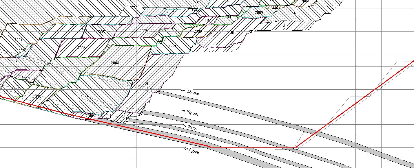 Mine surveyThe lion's share of the time in surveying is the provision of drilling and blasting operations, which includes issuing the basics for designing boreholes, surveying actual wells, analyzing the correspondence of the fact and plan of drilling, closing drilling volumes and the volume of blasted rock mass.At the request of the Customer, a specialized BVR accounting module was developed that uses an external database for design and actual boreholes, the use of which not only allows you to perform all the necessary work in a shorter time without the use of classical tools and supplies (ink and pen), but also ensures compliance of output results with current norms and rules. This module is currently successfully used at two Russian enterprises.
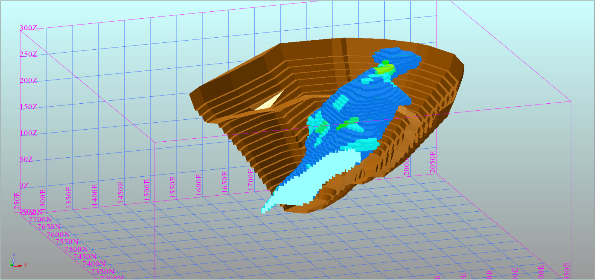
 Copying from the mining plan for the design of BVR
Especially for the geological services that update the geological data and ore preparation, tasks were set up, writing algorithms and implementing a set of tools to harmoniously combine modern three-dimensional modeling technologies and the long-established workflow at enterprises. This avoided the rejection of new technologies in enterprises with a rich history of successful existence. Moreover, such an approach to the implementation of software appealed to specialists of the old school who had no previous experience with GIS.GEOVIA specialists have extensive experience working on production sites, which allows you to really assess the needs of the market and anticipate the wishes of customers, offering them additional functionality developed using their own algorithms. One of the most striking examples is the module for calculating the weighted average planned distances and elevations for transporting rock mass by types and directions. This module (Fig. 3) turned out to be quite in demand, and today it is already used at several enterprises with minor changes. An additional convenience of the module, noted by users, is the possibility of constructing a longitudinal profile of roads (Fig. 4), in accordance with building codes and rules, and highlighting color of problem areas with an overestimated slope.For GIS, this proposal is unique today. Menu of the module “Calculation of distances”
 Longitudinal road profile
 For geologists who use the classical method of extracting ore intervals by the method of cuts in calculating reserves, a specialized module has been developed that combines the use of an external geological database, a standard set of Surpac tools and classical mathematical and logical expressions of ore extraction and non-metallic intervals recorded using TCL.Flexibility Surpac software sets this package apart from its competitive products.Due to the possibility of adapting the acquired software to your needs, the Client gets the opportunity to organically integrate new technology into the processes existing in the enterprise.In addition, as a result of reducing the influence of the human factor on the data processing process, the number of non-system errors is reduced to zero, providing confidence in the results. The possibility of formalizing processes and results allows us to bring input and output data to uniformity.In today's world, the demand for GIS is growing, which allows us to solve a set of related tasks in a single information space. This is exactly what has been successfully implemented by the specialists of the Russian division of GEOVIA in Surpac software due to the development of embedded specialized applications.Subscribe to Dassault Systèmes news and stay up to date with innovation and modern technology.Dassault Systèmes officialFacebook page ofVkontakteLinkedin3DS Blog WordPress3DS Blog on Render3DS Blog on Habr
Source: https://habr.com/ru/post/undefined/
All Articles